 Balanced Tangential Model
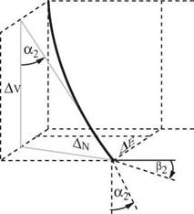
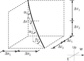
This model uses the survey data from both the upper and lower stations. The model assumes that the well path lies along two equal length, straight line segments. The inclination and direction of each segment is given by the corresponding survey station. The tangential model is therefore applied twice — once to the upper half, once to the lower half (Figure 4). This model approximates more closely to the probable shape of the wellbore and yields more accurate results (especially if the angles are changing rapidly).
|
|
|
Figure 3 Tangential Model |
|
E |
|
Up |
|
N |
W
|
|
|
Figure 4 Balanced Tangential Model |
|
N |
|
|
2.3.2 Average Angle Model
In this model the inclinations and the directions at the two survey stations are averaged. The wellbore is then assumed to be one straight line over the survey interval having this average direction and inclination. This straight line path is a good approximation provided the survey interval is small, and the rate of curvature is small in the actual wellbore (Figure 5). This model is often used at the rig site since the calculations are fairly simple.


