 DEPTH REFERENCE AND GEOGRAPHICAL REFERENCE SYSTEMS
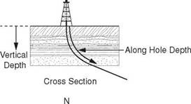
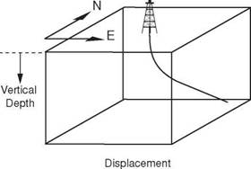
The trajectory of a deviated well must be carefully planned so that the most efficient trajectory is used to drill between the rig and the target location and ensure that the well is drilled for the least amount of money possible. When planning, and subsequently drilling the well, the position of all points along the wellpath and therefore the trajectory of the well must be considered in three dimensions (Figure 2). This means that the position of all points on the trajectory must be expressed with respect to a three dimensional reference system. The three dimensional system that is generally used to define the position of a particular point along the wellpath is:
• The vertical depth of the point below a particular reference point
• The horizontal distance traversed from the wellhead in a Northerly direction
• The distance traversed from the wellhead in an Easterly direction
|
|
|
Figure 2 Well Planning Reference Systems |
The depth of a particular point in the wellpath is expressed in feet (or meters) vertically below a reference (datum) point and the Northerly and Easterly displacement of the point is expressed in feet (or meters) horizontally from the wellhead.
|
|


